
Accurate aerial information has become increasingly important for industries that require fast situational awareness, precise positioning, and efficient field operations. Traditional surveying and inspection methods often require extensive manpower and time, especially when dealing with large areas or complex environments. With advances in artificial intelligence and unmanned aerial vehicle technology, orthomosaic drone mapping has emerged as a powerful approach for transforming aerial imagery into detailed spatial information.
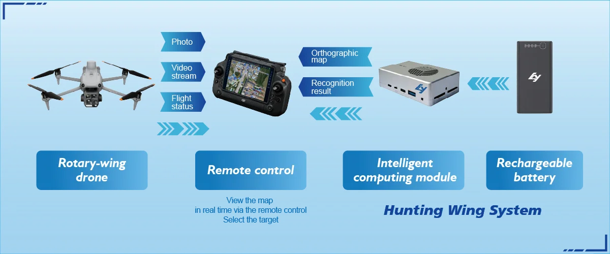
By combining drone platforms, AI processing, and intelligent recognition technologies, modern mapping solutions can provide more than visual data. They can generate accurate geographic outputs, identify important objects, and support faster decision-making. Icecypress Technology applies spatial intelligence and AI technologies to develop advanced UAV solutions, including Hunter Wing, a man-portable UAV system designed for drone reconnaissance, recognition, and real-time mapping applications.
Understanding the Workflow Behind Orthomosaic Drone Mapping
Orthomosaic drone mapping is a process that converts multiple aerial images captured by drones into a single high-resolution map with accurate spatial information. Unlike standard aerial photography, orthomosaic technology corrects image distortions caused by terrain, camera angles, and flight conditions, creating a consistent and measurable representation of the real environment.
The workflow usually begins with mission planning. Operators define the target area, flight path, altitude, and image overlap requirements before the drone begins data collection. During the flight, the UAV captures a series of images from different positions to ensure sufficient coverage.
After image collection, specialized algorithms process the captured data. The system identifies matching points between images, calculates spatial relationships, and combines individual photographs into a unified orthomosaic map. This digital output can then support inspection, monitoring, and operational planning.
Data Collection: The Foundation of Accurate Drone Mapping
The quality of an orthomosaic map depends heavily on the accuracy and efficiency of aerial data collection. Professional UAV systems need stable flight performance, reliable imaging capabilities, and precise positioning technologies to capture usable information.
For industrial applications, portability and deployment speed are also critical factors. A lightweight UAV solution allows teams to quickly perform missions in remote or challenging environments without relying on complex equipment setups.
Hunter Wing from Icecypress Technology is designed as a man-portable UAV solution that supports reconnaissance missions while integrating real-time orthomosaic drone mapping capabilities. The system provides operators with fast access to spatial information during field operations, helping improve awareness and response efficiency.
From Aerial Images to Intelligent Spatial Information
After drone imagery is collected, AI technologies play an important role in transforming raw images into valuable intelligence. Traditional mapping processes often focus on creating visual representations, but AI-powered systems can add deeper understanding to spatial data.
Through advanced algorithms, drone platforms can analyze captured information, identify key features, and generate structured outputs. This allows operators to understand not only where objects are located but also what those objects represent.
This is where drone object detection becomes an important capability. By applying artificial intelligence models to aerial imagery, systems can automatically recognize and locate specific targets. This reduces manual observation workloads and helps teams respond faster in time-sensitive situations.
How Drone Object Detection Enhances Field Operations
Drone object detection enables UAV systems to move beyond simple image capture and become intelligent recognition platforms. In emergency response, security patrols, and environmental inspections, quickly identifying objects or changes in an area can significantly improve operational outcomes.
For example, rescue teams can use AI-powered detection to locate important targets during complex missions. Security teams can monitor designated areas more efficiently, while inspection teams can identify potential issues without conducting lengthy manual searches.
Hunter Wing integrates drone reconnaissance, recognition, and positioning capabilities into a lightweight system. By connecting an AI Computing Box with a drone remote control, operators can quickly establish on-site situational awareness without modifying existing drone hardware or requiring extensive professional training.
A Flexible UAV Solution for Multiple Application Scenarios
Industrial operations often require technology that can adapt to different environments. A practical drone solution should provide reliable performance while remaining easy to deploy across various scenarios.
Hunter Wing is designed with all-scenario compatibility in mind. The system works with mainstream industrial drones and uses a plug-and-play approach that simplifies deployment. Its lightweight design allows a single operator to carry and operate the solution, improving flexibility in field applications.
This makes it suitable for public safety, emergency rescue, security monitoring, and environmental inspection tasks. By combining orthomosaic drone mapping with AI recognition capabilities, the solution helps organizations obtain accurate spatial intelligence when and where it is needed.
Improving Decision-Making Through Real-Time Spatial Intelligence
The true value of drone mapping technology lies in how quickly information can support decisions. In complex operational environments, delayed data can limit response capabilities. Real-time processing and intelligent analysis allow teams to understand situations faster and take more effective actions.
Icecypress Technology focuses on developing visual spatial intelligence solutions that connect aerial data collection with AI-driven analysis. Through integrated technologies, organizations can transform low-altitude data into actionable information for practical business and operational needs.
As industries continue to demand faster, safer, and smarter workflows, intelligent UAV systems will become increasingly important tools for digital transformation.
Building Smarter Operations with Intelligent Drone Mapping
Orthomosaic drone mapping has evolved from a simple aerial surveying method into a complete workflow that combines data acquisition, AI processing, and intelligent recognition. By integrating drone object detection, precise positioning, and real-time analysis, modern UAV solutions provide stronger support for professional operations.
Icecypress Technology’s Hunter Wing demonstrates how lightweight and intelligent UAV systems can improve reconnaissance and field awareness. For organizations seeking efficient spatial intelligence solutions, advanced drone mapping technologies offer a practical path toward safer operations, faster decisions, and enhanced management efficiency.